Integrating Google Earth as a Virtual Reality Platform in your classroom
Intro
Using Google Earth for grade 3 social studies in showing the terrain in various areas like India and Peru, and how these terrain levels influence societal decisions. At the same time, within a day or two, ask the class to use Google Earth to calculate perimeters around features of the city – like around a block, around a building, or an entire city.
Curriculuar Outcomes and Demographic items
Grade 3 Social Studies Outcomes (connecting the world):
(https://education.alberta.ca/media/456082/sockto3.pdf)
GLO 3.1 Students will demonstrate an understanding and appreciation of how
geographic, social, cultural and linguistic factors affect quality of life in communities in India, Tunisia, Ukraine and Peru.
SLO 3.1.3 : Students will demonstrate an understanding and appreciation of how
geographic, social, cultural and linguistic factors affect quality of life in communities in India, Tunisia, Ukraine and Peru.
a) Students will demonstrate an understanding and appreciation of how
geographic, social, cultural and linguistic factors affect quality of life in communities in India, Tunisia, Ukraine and Peru .
b) How does the physical geography influence the human activities in the communities
Grade 3 Math Outcomes:
(https://education.alberta.ca/media/645594/kto9math.pdf)
(Shape and Space/ Measurement unit)
GLO: Use direct and indirect measurement to solve problems.
SLO 5: Demonstrate an understanding of perimeter of regular and irregular shapes;
b) measuring and recording perimeter
Activities and Hook
Setup
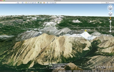
Create or find a Tour KMZ path file for Google earth that will take the students through a virtual tour of the region intended for study. The tour feature will create a camera view along any path you draw, so that you become a plane or helicopter pilot flying through the region. This gives the students a birds-eye view of the changes from one area to another (ie. from plains to mountains), showing the different terrain features, water ways, and important aspects for a livable region.
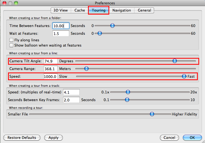
The preferences for Google Earth can be refined to change speed, camera view angle (how much horizon or ground is visible), and if you create landmarks along the way, how long to wait at each feature, and more. See Figure 1 for example settings that I use.
Create a second path around a city block, building, or similar feature for use in learning perimeter.
Activity 1
Try and get the students to describe what it would be like to fly through a region such as the plains of India into the Himalayas; likely there will be some ambiguity, confusion, and shrugging of shoulders. Then turn on the tour created, and get them to experience the terrain, asking them to image what it would be like with different weather like rain, snow, sun – etc. This leads into a discussion about how these features affect the way in which people live in the area, and what kind of farming they do.
Activity 2
Using a second path of a regular rectangle, slow down the speed, then “walk” around the perimeter of a building or region, with a transition into using the path for finding the actual length of a side, which can be used for perimeter.
VR Integration ideas & description
Book the laptop or iPad cart into your classroom, (making sure Google Earth is installed on all of the devices beforehand).
Prepare a mini-lesson on showing the students how to open Google Earth, locating your hometown, zooming in and out, and navigating around the region. Demonstrate how to create placemarks and paths, and how to go back to them at a later date.
Give the students a device each, so that they can explore and learn how to use the software, helping and guiding along the way as needed.
Once students have found their hometown, and maybe even the school or their house, or other prominent local features, have them go to the specific area you are studying, like India or Peru.
If needed to explain how a round earth can be shown on a flat map, this animation somewhat shows how the flat map is stretched and deformed into a sphere https://www.youtube.com/watch?v=uLuVfOtBXd0.
Rationale for Application, duration, benefits, problems
Rationale
Google earth is a common and free software, used by many people at home and in businesses. It is a powerful tool, which has many layers of extension including road maps, photos, 3D buildings, wikipedia articles, geological activity, and even under water or space exploration. This virtual environment can have many different educational uses in social study and earth sciences. It is a fun and easy way to get students involved and engaged in their education around these topics. Another benefit of the satellite imagery is to show current event issues which are typically hidden from the common public’s eye – things like large-scale forestry, mining, city growth, water and glacial recession. It is the next best thing to being in some interesting archeological areas.
Number of lessons
This will be dependent on the length of your period, and how many minutes you have to teach and explore. The first lesson will at least include the hook activity, and learning how to use Google Earth; if more time is available, then you can tour around the areas you want to explore. These explorations will likely be full of excitement and discussion.
Google Earth can be used in many situations, as the class progresses through the four main regions studied this year – so a minimum of 4 years
Expected problems
Some of the expected problems which might arise include internet bandwidth – having 20-30 devices all accessing the high-resolution imagery available at the same time might be problematic for some school internet connections. It is likely that there will be performance issues with older or cheaper/slower laptops being able to give a dynamic experience – turning off water surface if not needed, and turning down 3D settings in the application preferences might help a little.
There might also be problems with IT getting the software installed if needed, especially if there are many security and filtering mechanisms in place.
Some students might really struggle with 3D navigation at a grade 3 level, especially with a trackpad on a laptop compared to a mouse – perhaps have a few USB mice available in the classroom for use.
Rationale for Generic VR for learning
In general terms, there are some classes which can benefit greatly from some form of virtual reality – wether it is a social studies or geography lesson using Google Earth, some math classes using different programming environments like Alice or Blender; physics classes can make use of 3D worlds like Second Life/Open Sim or Blender for more advanced ideas. Whatever the class, there will be time and effort involved at the beginning to train the students, and to make sure all is working smoothly. But if it is done right, with a proper underlying reason and foundation, VR can be a very engaging and useful tool in a teacher’s toolbox. Students can learn, grow, interact, take creative risks, and explore things otherwise not accessible in a traditional classroom. There are always drawbacks, such as wrong type of motivation, cheating, apathy, lack of accountability, and more – but if done correctly, with good student and parent buy-in, can be a very helpful resource.
Assessment
Since the Google Earth platform is being used as a tool to assist learning, it could be used in a small handful of ways to help with assessment.
· ask students to find a unique feature in a region and submit the latitude and longitude coordinates.
· ask students to determine the perimeter of a specific building or region, and submit the answer.
· ask students to use Google Earth to show the areas they are studying to their parents at home and explain the features to them; have the parents sign a slip or agenda stating that they did so
· ask students to create their own path that would take them through a historical route, or migration path
Conclusions
Hopefully this example of Virtual Reality technology integration has been a helpful tool to help you in integrating Google Earth into your classroom. There are many pros, alongside a few drawbacks or potential hiccups. It can be used for Social Studies, Geography, Math, History, and earth sciences. It may or may not be directly useful for your assessments – it’s entirely up to you.
